Turkey is located in one of the most seismically active areas in the world, where the Eurasian Plate, the African Plate, the Arabian Plate and the Anatolian Plate meet. The complex interaction of plates has triggered devastating earthquakes many times in history. One of the most famous events was the 1939 Erzincan earthquake, which killed more than 30,000 people, and since then the earthquakes appear to have migrated westwards in a staircase along the North Anatolia Fault. Many scientific researchers therefore judge that the next major earthquake is most likely to occur under the Sea of Marmara south of Istanbul.
The North Anatolian Fault in the Marmara Sea has not experienced a major earthquake in more than 250 years, which has led to concerns in the scientific community that tectonic stress may have accumulated in the area over a long period of time. However, although relevant research has continued for decades, the fine structure of faults deep under the sea has always been difficult to clarify, which has largely restricted scientists from accurately judging the possible rupture locations of future earthquakes and providing more targeted suggestions for disaster prevention and mitigation.
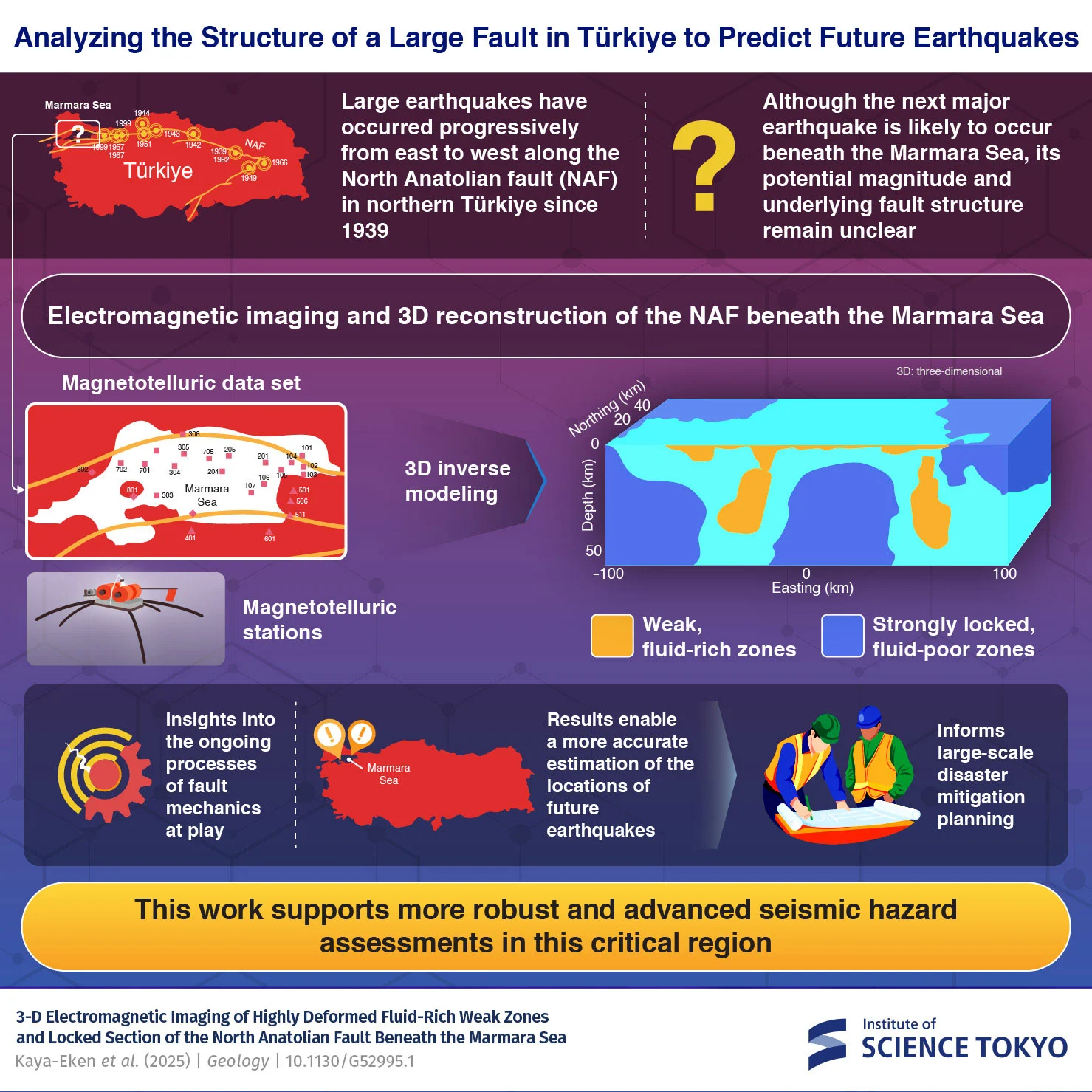
To fill this gap, Yasuo Ogawa, an emeritus professor at the Center for Multidimensional Resilience Research at the Institute of Comprehensive Studies at Tokyo University of Science, Japan, led a systematic survey of the area beneath the Sea of Marmara in collaboration with Tülay Kaya-Eken, an assistant professor at Bogazici University in Turkey. Relevant results were recently published in the journal "Geology". The research team constructed the first three-dimensional electromagnetic structure model covering this key area, providing a new perspective for understanding the relationship between the differences in physical properties within the fault and the breeding of earthquakes.
Unlike traditional methods that rely on seismic waves to "see through" underground structures, this research uses electromagnetic signals rather than seismic signals. The team compiled observational data from more than 20 previously deployed local magnetoresistance stations (magnetic geodetic sounding stations), which recorded the tiny impact of the earth's deep structures on the natural electromagnetic field. Using a three-dimensional inversion method, researchers reconstructed the electrical distribution within a depth of tens of kilometers beneath the Sea of Marmara, which is a three-dimensional image of the resistivity of the underground medium.
The analysis results show that the spatial distribution of resistivity in this area is extremely complex, with both band-shaped areas with significantly lower resistivity and "hard blocks" with significantly higher resistivity. Studies have pointed out that low resistivity is often associated with water-bearing or fluid-rich rocks, which are relatively "weak" in mechanics; on the contrary, high resistivity areas usually correspond to harder and more locked crustal blocks. It is this structure of strength and weakness that provides a potential stage for the gestation and rupture of future major earthquakes.
"Ogawa Yasuo said that the high resistance anomalies they observed represent locked areas where stress is accumulating. These characteristics provide key clues for understanding the fault mechanics process." The research team speculates that future large earthquakes are likely to initiate cracks at the boundaries of strong and weak zones, or at the edges of high-resistance "locked" zones. These locations are more likely to become weak links for stress concentration and rupture propagation.
The work is considered an important step toward answering a core question concerning the safety of tens of millions of residents in Türkiye: where exactly will the next major earthquake brew and erupt. Yasuo Ogawa pointed out that the newly constructed three-dimensional electromagnetic model can be used to evaluate the rupture initiation location and possible magnitude of potential giant earthquakes, providing a quantitative basis for future risk assessment and resilience planning. The researchers also emphasized that continued electromagnetic observations combined with other geophysical monitoring methods are expected to improve earthquake hazard predictions on long-term scales, thereby minimizing human casualties and economic losses before the next major rupture of the North Anatolia Fault arrives.