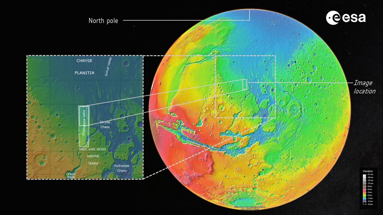
The European Space Agency recently released a new set of images from the "Mars Express" probe, focusing on the Shalbatana Vallis near the equator of Mars - a huge valley cut by super floods billions of years ago. The images show a complex landscape full of craters, lava flows and collapsed terrain and are thought to potentially hold important clues about Mars' ancient oceans.
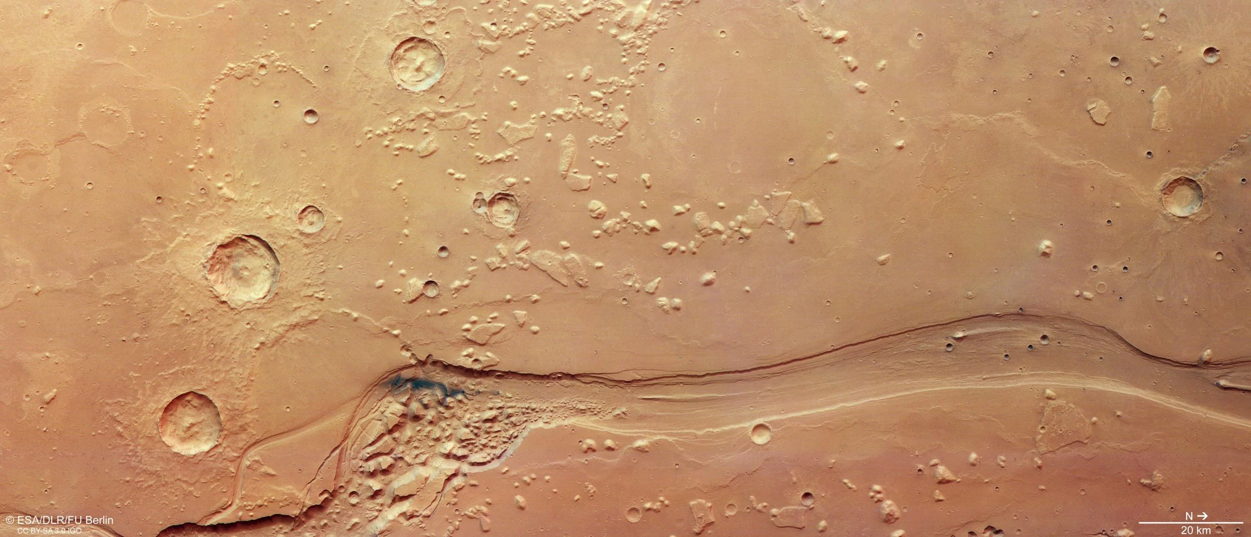
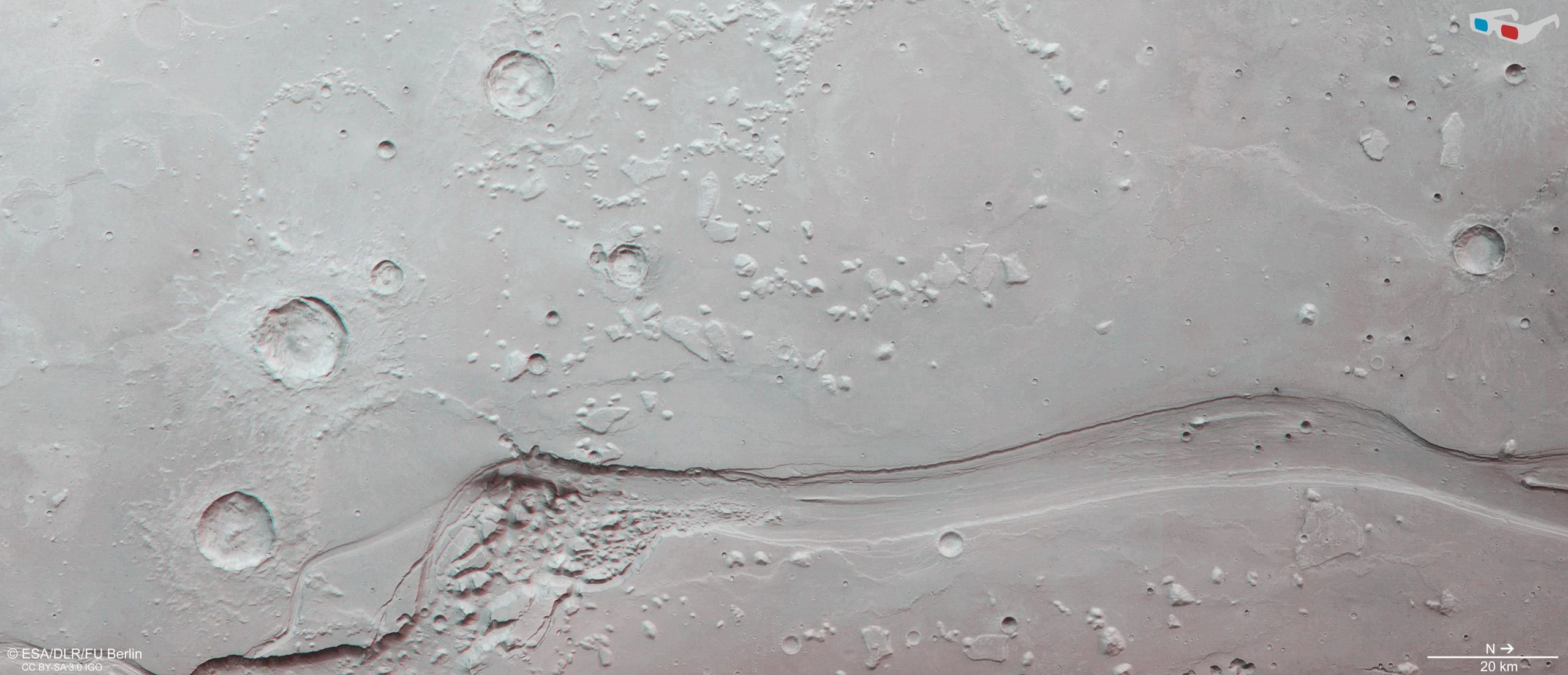
The Sabatana Valley is located near the equator of Mars and is about 1,300 kilometers long, roughly the same length as Italy. The image released this time was acquired by the High-Resolution Stereo Camera (HRSC) onboard the "Mars Express" and focuses on the northern section of the main valley, which is about 10 kilometers wide and 500 meters deep, and its surrounding environment. As can be seen in the picture, the main valley enters from the lower left corner of the image, and then curves northward out of the picture.
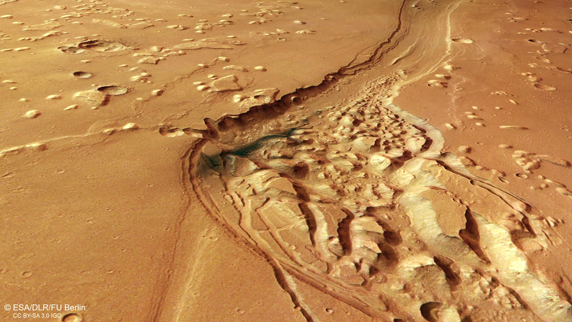
Scientists speculate that the Shabatana Valley was formed about 3.5 billion years ago, when large amounts of groundwater violently gushed out from beneath the surface of Mars. These rushing floods eroded the surface of the land in a very short period of time, rushing toward the lowlands and carving out deep and wide outflow channels. The researchers note that the valley may have originally been deeper than it is today, only to be partially raised as sediment and other material filled in over time. In a rougher section of the valley, you can see an extremely dark, almost blue-black patch, which is believed to be a deposit of volcanic ash that was later re-carried and reshaped by Martian winds.
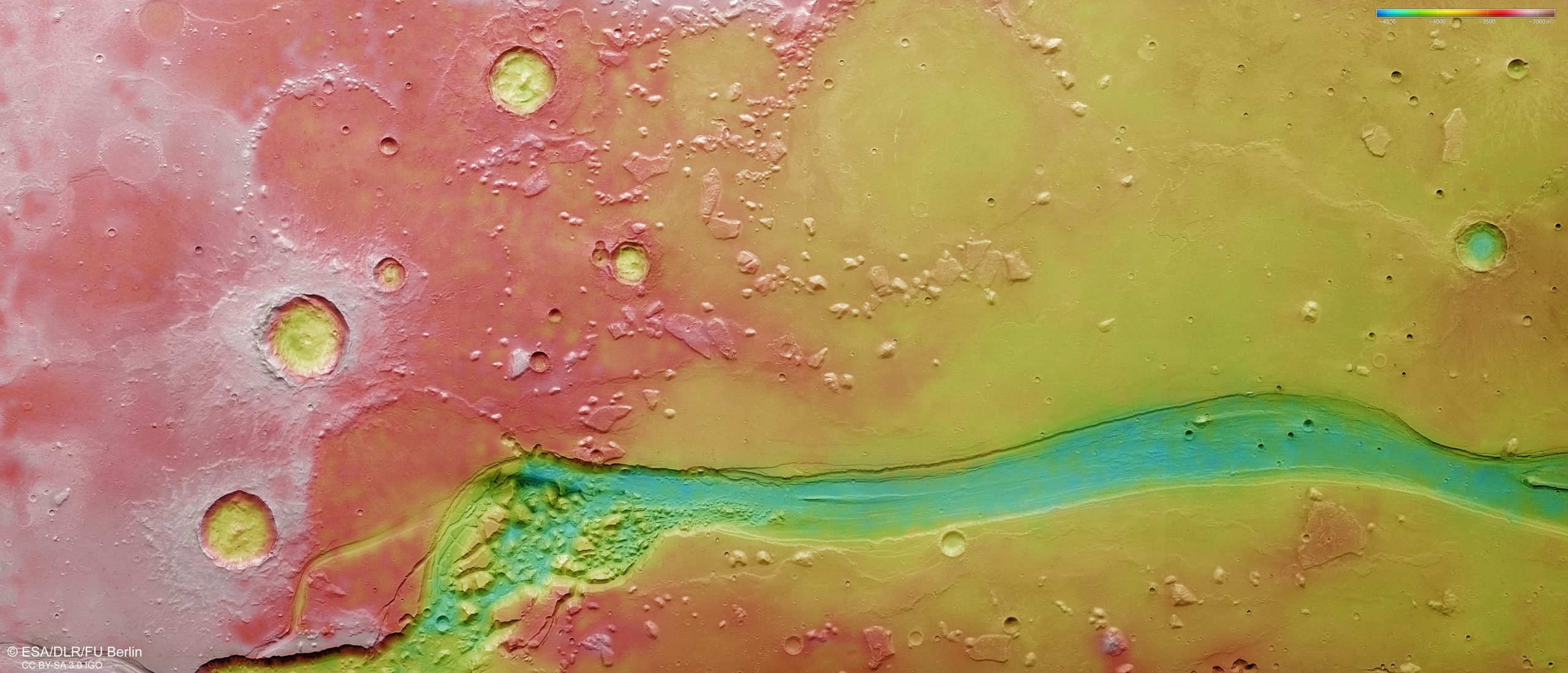
The Sabatana Valley does not exist in isolation, but is part of a larger outflow channel system on Mars. This area is located at the junction of the cratered highlands in the south and the relatively smooth lowlands in the north. Not far from the north is the famous Chryse Planitia. Chryse Planitia is one of the lowest regions on Mars and is where many large outflowing rivers eventually converge. Because of this, some scientists have suggested that this place may have been a vast ancient ocean in the early days when Mars was warmer and wetter.
In the images released this time, there are also rich and diverse geological structures around the Sabatana Valley, and these features are clearly marked on the annotated images. The "chaotic terrain" common on Mars is particularly typical in this area: the surface is fragmented and made up of a chaotic stack of rock blocks of different sizes, ridges and isolated mounds. This chaotic landscape is particularly noticeable in the wider section of the Shabatana Valley, near dark volcanic ash deposits.
The scientific research team believes that this type of chaotic terrain is likely to originate from the collapse process caused by melting underground ice. When a large amount of underground ice melts due to rising temperatures, and the "skeleton" supporting the overlying strata is weakened, the entire surface will collapse and break, forming today's chaotic and massive landforms. Similar terrain has been recorded by Mars Express in other areas of Mars in the past, including Pyrrhae Regio, Iani Chaos, Ariadnes Colles, Aram Chaos and Hydraotes Chaos.
In addition to the chaotic terrain, widespread impact craters are visible in the image. Some craters have been partially buried by later sediments, others have been rounded and obscured by long-term erosion, and some still retain accumulations of ejecta extending outward around the crater rim. These ejections are rock debris and dust ejected at the moment of impact, recording violent celestial impact events.
It is worth noting that large areas around the Sabatana Valley have a relatively smooth surface. Scientists judged from this that this area was once covered by a large area of lava flow. As the lava cooled and contracted, the surface produced rugged "wrinkle ridges," which appear as strips and folds in the image. At the same time, isolated highlands called "mesas" can also be seen in the upper right position of the image. They are "isolated islands" that are the remnants of ancient highlands. They are still standing on the relatively low surrounding surface after billions of years of erosion.
The images and digital terrain models displayed this time were obtained by the high-resolution stereo camera onboard the "Mars Express". Since its launch in 2003, this exploration mission has remained in Mars orbit for more than two decades, mapping the Martian surface in unprecedented detail in color and three-dimensional terms. Thanks to the long-term accumulation of data, scientists can systematically sort out the geological history and evolution of Mars, including water activity, volcanic activity, impact records, and possible traces of ancient oceans.
The high-resolution stereo camera was developed and operated by the German Aerospace Center (DLR), and its data are systematically processed at the DLR Space Institute in Berlin-Adlershof. Subsequently, the Planetary Science and Remote Sensing Group of Freie Universität Berlin used these data to produce various imaging products released this time, including color images, terrain shaded maps, and three-dimensional views. Through comprehensive analysis of these data, researchers were able to reconstruct the long evolution history of Mars from wet to dry, from active to dormant, in a valley carved by ancient floods.