Mexico City is trapped in a dangerous “vicious cycle.” As groundwater is continuously pumped out, the urban surface continues to sink, and the sinking rate is seriously uneven in different areas, with entire blocks collapsing at very different rates. This "unbalanced subsidence" tears water pipes, sewers and wells, causing leaks and huge water losses. Cities have to pump more groundwater to make up for the gap, further exacerbating ground subsidence.
The scientific community has noticed this problem as early as the last century. Mexican engineer Roberto Gayol first identified the phenomenon of land subsidence in Mexico City as early as 1925. Nearly a hundred years later, the National Aeronautics and Space Administration (NASA) and the Indian Space Research Organization (ISRO) have aimed one of the world's most powerful synthetic aperture radar systems at this slowly sinking megacity, trying to map the surface deformation with unprecedented accuracy.
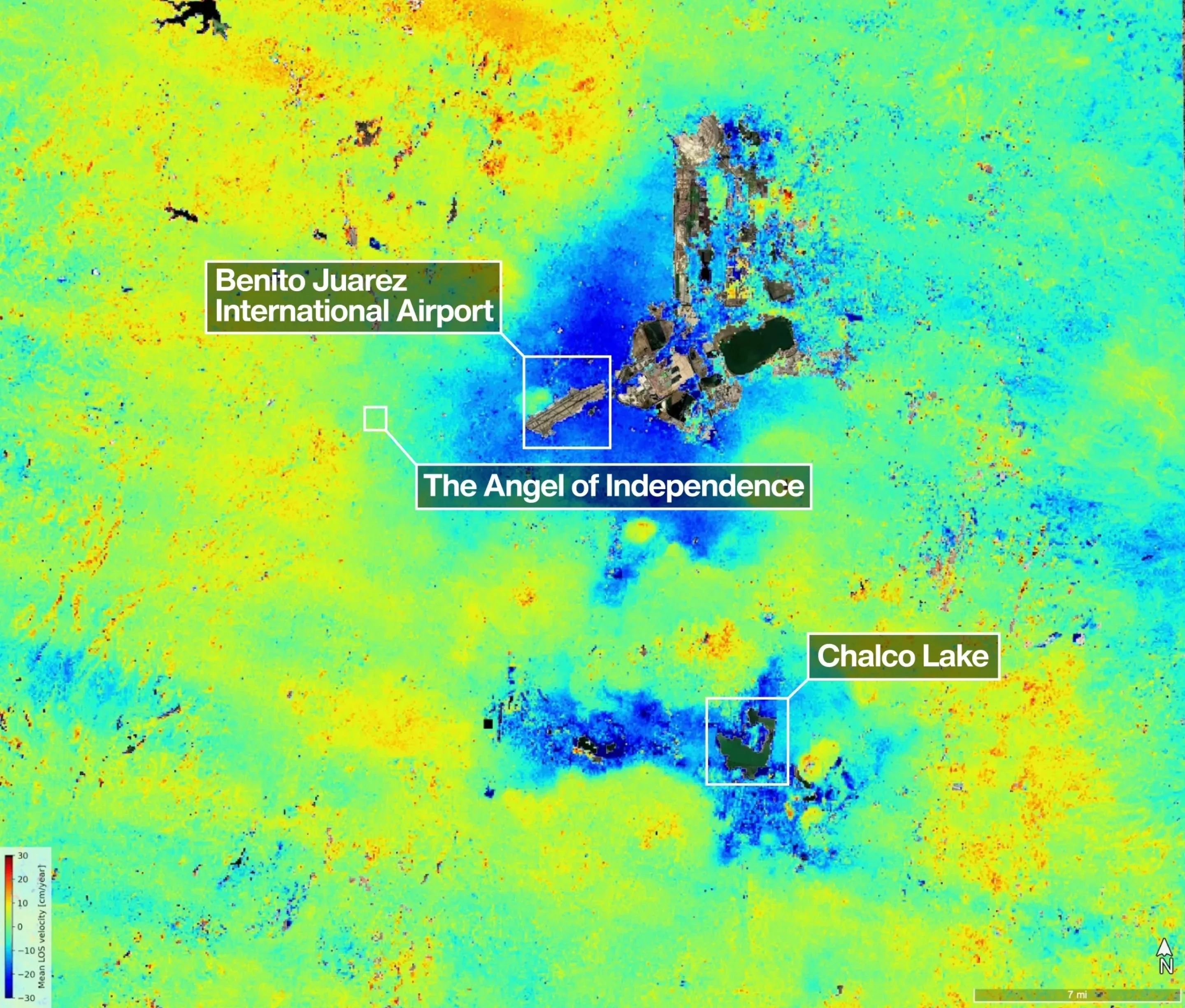
This satellite, called the "NASA-ISRO Synthetic Aperture Radar Satellite" (NISAR), can track subtle changes in the earth's surface with extremely high precision. In observations of Mexico City, it clearly revealed changes in the city's underground structure, marking some areas sinking more than half an inch (about 2 centimeters) per month. The latest radar images show that dark blue areas represent monthly subsidence of more than 2 centimeters, while yellow and red areas are considered "residual noise signals" that are expected to be gradually filtered out as NISAR accumulates more data.
Mexico City was originally the Aztec city-state of Tenochtitlan on Lake Texcoco in the 14th century. The lake was gradually drained over the following hundreds of years, but today's Mexico City still sits on an aquifer filled with groundwater. Since land subsidence was first recognized in 1925, the capital's population has grown to more than 22 million, driving demand for water soaring. One report points out that groundwater extraction now accounts for about 60% of Mexico City's total water supply, exacerbating the problem of land subsidence.
One detail stands out in NISAR's latest images: Mexico City's Benito Juarez International Airport is located squarely within a dark blue area of high subsidence. NASA deputy project manager Craig Ferguson said images like this prove that NISAR measurements are as expected. Looking more broadly, this is not the only critical transportation infrastructure affected: as early as 2021, a section of a subway viaduct collapsed due to structural failure, killing 26 people. One of the causes of the accident was blamed on the long-term erosion and damage of one of the busiest urban rail systems in the Americas by ground subsidence.
As one of the most expensive earth imaging satellites currently, NISAR is equipped with a deployable radar reflection antenna with a diameter of about 12 meters, which is the largest radar antenna NASA has ever sent into space. The satellite repeatedly observes the Earth's surface at a high frequency and can scan the Earth twice every 12 days, providing unprecedented temporal and spatial resolution for continuous monitoring of surface deformation. The image data collection used to analyze the subsidence of Mexico City lasted from October 2025 to January 2026, outlining the deformation trajectory of the city in just a few months.
The threat of "differential subsidence" has been manifested in many places around the world, with Mexico City being a typical case. In 2024, Mexico City's tap water supply was once considered to have only a few months of safety buffer period left. The water crisis forced the city to rely further on groundwater extraction, thus intensifying the previous vicious cycle. In the same year, Dario Solano-Rojas, a remote sensing expert at the National Autonomous University of Mexico, published a study focusing on the serious "differential subsidence" problem in Mexico City. The study shows that in the same city, some areas have an annual sinking rate of up to 50 centimeters, while other areas are almost stationary. This severe uneven deformation brings huge safety risks to cross-regional infrastructure.
The danger of differential settlement is that many large infrastructure systems often span multiple sections: a subway tunnel may pass through areas with completely different settlement rates. If a certain section of roadbed continues to sink rapidly while adjacent sections barely move, huge additional stresses will be generated on the structure, and even cause the tunnel or bridge to collapse. Scientists hope that the high-precision data provided by NASA and ISRO will help identify these high-risk areas, thereby providing a basis for engineering reinforcement and urban planning to avoid future tragedies.
NISAR's global observation capabilities also mean that similar high-precision subsidence maps are likely to appear in other "sinking cities" in the future. The article points out that people should not be surprised to see NISAR radar images of Jakarta in the news in the near future. The Indonesian capital is also built on multiple aquifers and is known as "the world's fastest sinking city." Its infrastructure is also seriously threatened by differential subsidence. Unlike Mexico City on the inland plateau, Jakarta is a low-lying coastal city. The combination of subsidence and sea level rise makes the risk more severe. Some estimates suggest that about 40% of Jakarta is already below sea level.
David Bekal, a member of the NISAR scientific research team, emphasized that Mexico City is just one of the satellite's many "hot spot observation targets". With its unique detection capabilities and stable global coverage, mankind will usher in a wave of new discoveries from all over the world. Compared with Mexico City and Jakarta, Venice, another "famous sinking city", appears to be much "moderate". Due to strict local restrictions on groundwater extraction, Venice's annual subsidence rate is roughly controlled within the range of 1 to 2 millimeters. Even so, for residents of any slowly sinking city, fine measurements from advanced satellite radars are significant: they can't stop the sinking, but they can save lives by exposing structural weaknesses before danger accumulates to a breaking point.
Ferguson pointed out that the long-band L-wave radar used by NISAR is particularly good at detecting surface deformation in areas with dense vegetation and complex environments, which is particularly critical for coastal communities that face the dual pressure of both land subsidence and sea level rise. With the help of this kind of data, researchers and city managers can develop more targeted response plans, prioritize strengthening vulnerable infrastructure, and buy time for urban security in the coming decades.