According to news released by the National Aeronautics and Space Administration (NASA), as sea temperatures in the central and eastern equatorial Pacific Ocean continue to rise, a strong climate signal is quietly forming in the tropical Pacific. Starting from June 11, 2026, the National Oceanic and Atmospheric Administration (NOAA) officially announced the return of El Niño after sea surface temperatures in the area have been at least 0.5 degrees Celsius higher than normal for several months.
In addition to traditional temperature monitoring, NASA and its partners are using satellite technology to capture another core warning signal of this climate phenomenon from a space perspective—abnormal changes in sea surface height.
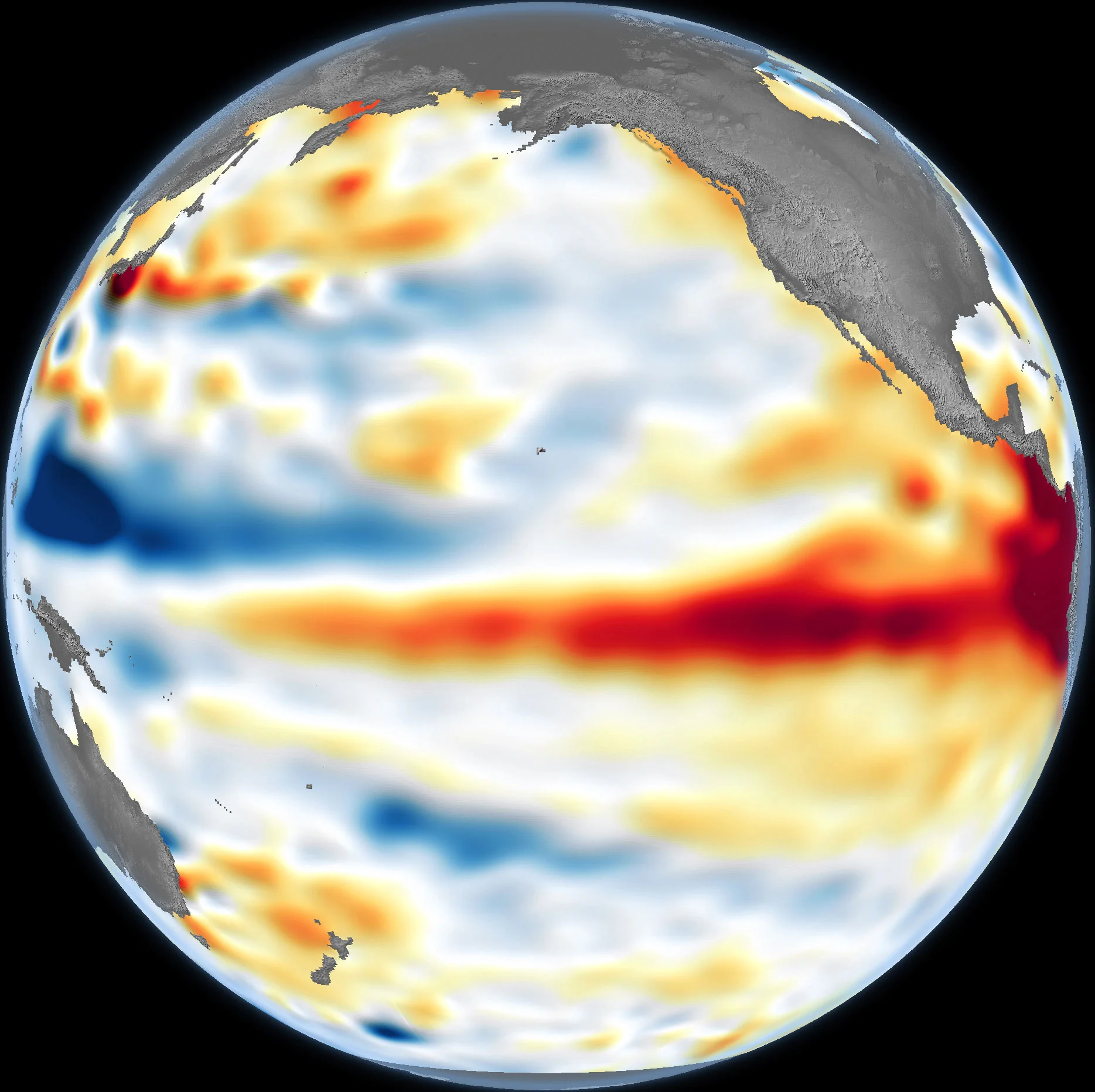
Scientists pointed out that warm water has the characteristics of thermal expansion and contraction. When a large amount of warm water expands on the surface of the Pacific Ocean, satellites can detect subtle rises in sea level. This data goes beyond surface details and reveals how much heat the oceans store deep down, which will be critical to assessing whether El Niño has enough power to reshape global weather patterns in the coming months.
El Niño can significantly change the paths of rainfall, heat waves and storms around the world. Its most common impacts include increasing the chance of precipitation in the southwestern United States while exacerbating drought risks in the western Pacific, such as Australia and Indonesia. This impact typically peaks during the Northern Hemisphere winter, when climate changes in the tropical Pacific have a ripple effect through atmospheric circulation, triggering weather anomalies around the globe.
In order to accurately capture this deep dynamic, scientific researchers used the "Sentinel-6" Michael Freilich satellite to collect sea surface height data, and eliminated seasonal fluctuations and long-term sea level change trends, thereby making the El Niño signal more prominent. Monitoring shows that this spring, huge pulses of warm water called "Kelvin waves" appeared in the equatorial region of the Pacific Ocean. These waves moved from west to east and were an early sign of the formation of El Niño. Normally, when trade winds weaken or reverse, warm water originally accumulated in the western Pacific flows back toward the American continent.
As the warm water moves eastward, the warm water layer on the ocean surface deepens, and the thermocline decreases, hindering the normal upwelling of cold water along the Pacific coast of the Americas, making the ocean surface seem to be covered with a thick "heat blanket." Scientists emphasize that compared with the fleeting thin layer of warm water, this deep heat storage is more difficult to disturb and is sufficient to support the long-term persistence and strengthening of the El Niño phenomenon.
Regarding the 2026 El Niño event, Séverine Fournier, a researcher at NASA's Jet Propulsion Laboratory (JPL), pointed out that the currently monitored conditions in the western Pacific are quite similar to the early stages of the strongest El Niño event in history that occurred in 1997. However, since the number of Kelvin waves observed as of June 8 is less than that of the same period in 1997, the current warming level in the Eastern Pacific is still slightly lagging behind. But observational data show that there are still more warm water pulses moving eastward, which means that the intensity of the phenomenon is still growing. Currently, the scientific research team is paying close attention to the interaction between the ocean and the atmosphere to further assess whether its final size will be comparable to historical records.