Submarine canyons are among the most striking and complex geological structures on the ocean floor, yet many of them remain poorly understood, especially those in remote polar regions such as the Arctic and Antarctic."Marine Geology"A recent paper published in the journal provides the most comprehensive inventory of Antarctic submarine canyons to date, documenting 332 canyon systems, some of which are more than 4,000 meters deep.
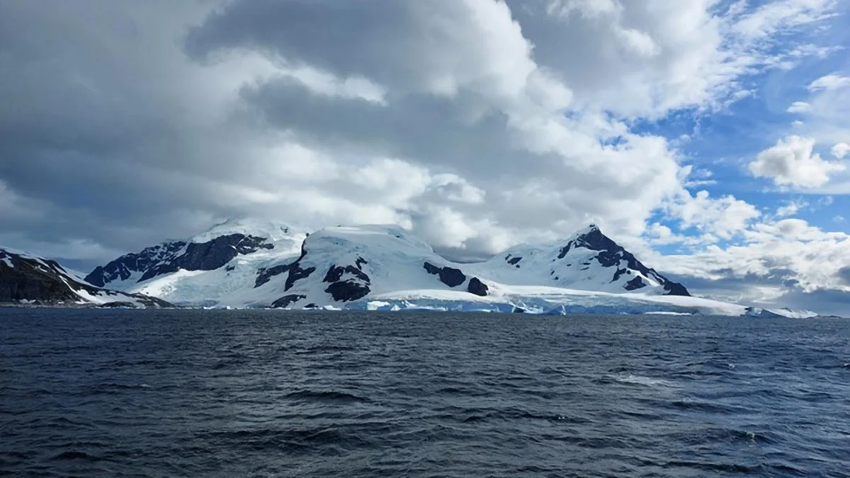
Submarine canyons form on the ocean floor and play a decisive role in ocean dynamics. Image credit: Marc Cerda, University of Barcelona
The new catalog, which identifies five times as many canyons as previous surveys, was compiled by David Amblàs from the Integrated Marine Earth Sciences Research Group at the School of Earth Sciences at the University of Barcelona and Riccardo Arosio from the Marine Earth Sciences Research Group at University College Cork. Their results suggest that Antarctic submarine canyons may play a greater role than previously appreciated in influencing ocean currents, ice shelf thinning, and broader climate dynamics, particularly in sensitive regions such as the Amundsen Sea and East Antarctica.
Submarine canyons are deep valleys cut into the ocean floor and are key features that influence ocean processes. They transport sediments and nutrients from coastal areas to the deep ocean, connecting shallow and deep waters and supporting biodiversity-rich ecosystems. Although approximately 10,000 submarine canyons have been discovered worldwide, only 27% of the seafloor has been mapped at high resolution, meaning that many more canyons remain undiscovered. Despite their importance to marine ecology, ocean circulation, and geology, these canyons—especially those in the polar regions—remain understudied.
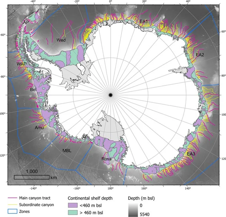
A new high-resolution catalog identifies a network of 332 submarine canyons on the Antarctic continent's seafloor. Image source: University of Barcelona
"Like canyons in the Arctic, Antarctic submarine canyons are similar to canyons in other parts of the world," explains David Amblàs. "But they tend to be larger and deeper due to the long-term action of polar glaciers and the large amounts of sediment transported by glaciers to the continental shelf." In addition, Antarctic canyons are mainly formed by turbidity currents, which wash suspended sediment downhill at high speeds, eroding the valleys they flow through. In Antarctica, the steep slope of the seafloor topography coupled with abundant glacial sediments amplifies the effects of these turbidity currents and contributes to the formation of large canyons.
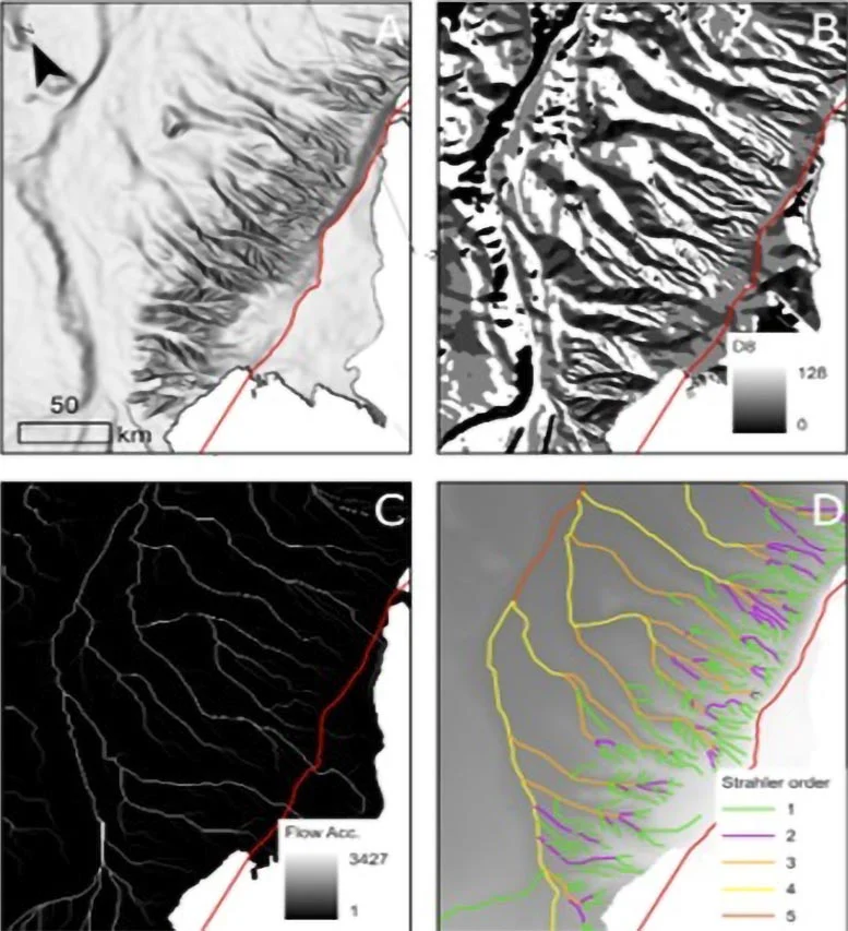
Amblàs and Arosio's latest research draws on the second edition of the International Bathymetric Chart of the Southern Ocean (IBCSO v2), which provides the most comprehensive and detailed seafloor map of the region. The study integrates newly acquired high-resolution bathymetric data and uses semi-automated techniques developed by the authors to detect and analyze submarine canyons. In their analysis, they examined 15 morphological parameters, revealing significant differences between East Antarctica and West Antarctica canyon systems.

The catalog, which identifies five times as many canyons as previous studies, was compiled by David Amblàs of the Integrated Marine Earth Sciences Research Group at the School of Earth Sciences at the University of Barcelona and Riccardo Arosio of the Marine Earth Sciences Research Group at University College Cork. Image source: University of Barcelona
"Some of the submarine canyons we analyzed were more than 4,000 meters deep," explains David Ambras. "The most spectacular of these canyons are found in East Antarctica and are characterized by complex branching canyon systems. These canyon systems often begin in multiple canyon sources near the edge of the continental shelf, converging into a main channel that traverses the steep slopes of the continental slope and ultimately extends into the deep ocean."
Ricardo Arosio points out: "It is particularly interesting to observe the differences between Antarctica's two major regional canyons, as this difference has never been described before. East Antarctica canyons are more complex, branching out, often forming extensive systems of canyon channels, and having a typical U-shaped cross-section. This suggests that these canyons have experienced long-term development under continued glacial activity and are more affected by erosion and sedimentation. In contrast, West Antarctica canyons are shorter and steeper, and are characterized by a V-shaped cross-section."
David Amblàs believes that this morphological difference supports the idea that the East Antarctic ice sheet originated earlier and experienced a longer development. "Studies of the sedimentary record have suggested this idea," Ambras said, "but large-scale seafloor geomorphology studies have not described it."
Antarctic canyons also facilitate the exchange of water between the deep ocean and the continental shelf. Image source: Marine Geology
Regarding the study, Riccardo Arosio also explains: "Thanks to the high resolution of the new bathymetric database - 500 meters per pixel, compared to the previous map resolution of 1-2 kilometers per pixel - we can more reliably apply semi-automated techniques to identify, profile and analyze submarine canyons. The strength of this study is that it combines various techniques that have been used in previous studies and are now integrated into a powerful and systematic scheme. We also developed a GIS Software scripts can calculate a variety of canyon-specific morphological parameters in just a few clicks."
In addition to their striking appearance, Antarctic submarine canyons play a vital role in transporting water between the deep ocean and the continental shelf. They help transport cold, dense water formed near ice shelves to the deep ocean, where Antarctic bottom waters form — a key component that regulates ocean circulation and influences global weather patterns.
These canyons also channel warmer currents, such as deep circumpolar water, from the high seas to the Antarctic coastline. This movement is a major factor in the melting and thinning of floating ice shelves, which are critical for stabilizing inland glaciers. As Ambras and Arosio point out, when these ice shelves weaken or break off, glacial ice flows into the ocean faster, directly contributing to sea level rise.
Amblàs and Arosio's research also highlights that current ocean circulation models, such as those used by the Intergovernmental Panel on Climate Change, do not accurately reproduce the physical processes that occur between water masses and complex terrain such as canyons at local scales. These processes, including current gulling, vertical mixing and deep-water ventilation, are critical to the formation and transformation of cold, dense water masses such as Antarctic bottom water. Ignoring these local mechanisms limits the ability of models to predict changes in ocean and climate dynamics.
As the two researchers conclude, "This is why we must continue to collect high-resolution bathymetric data in unmapped areas that are bound to reveal new canyons, collect observations in situ and via remote sensors, and continuously improve our climate models to better represent these processes and increase the reliability of predictions of climate change impacts."
Compiled from /scitechdaily