On September 21, 2025, the Hong Kong Polytechnic University research team used innovative forward modeling technology to overcome the problem of low spatial resolution in satellite laser ranging and achieve long-term monitoring of global ocean quality changes. Research shows that the rise in global mean sea level (GMSL) is mainly driven by the growth of ocean mass, and the melting of land glaciers has become the dominant factor in current sea level changes.
The research team used innovative forward modeling technology to break through the spatial resolution limit of satellite laser ranging and achieve long-term monitoring of global ocean quality changes. Source: Hong Kong Polytechnic University
Researchers at the Hong Kong Polytechnic University used advanced spatial benchmark measurement technology to provide for the first time an accurate 30-year record of global ocean mass changes (i.e., gravity hydrostatic sea level) from 1993 to 2022. The analysis found that changes in ocean mass play a leading role in driving sea level rise.
Data show that the global average sea level has risen at a rate of about 3.3 millimeters per year over the past 30 years, showing a clear acceleration trend, highlighting the increasingly serious impact of climate change. Relevant results have been published in the Proceedings of the National Academy of Sciences.
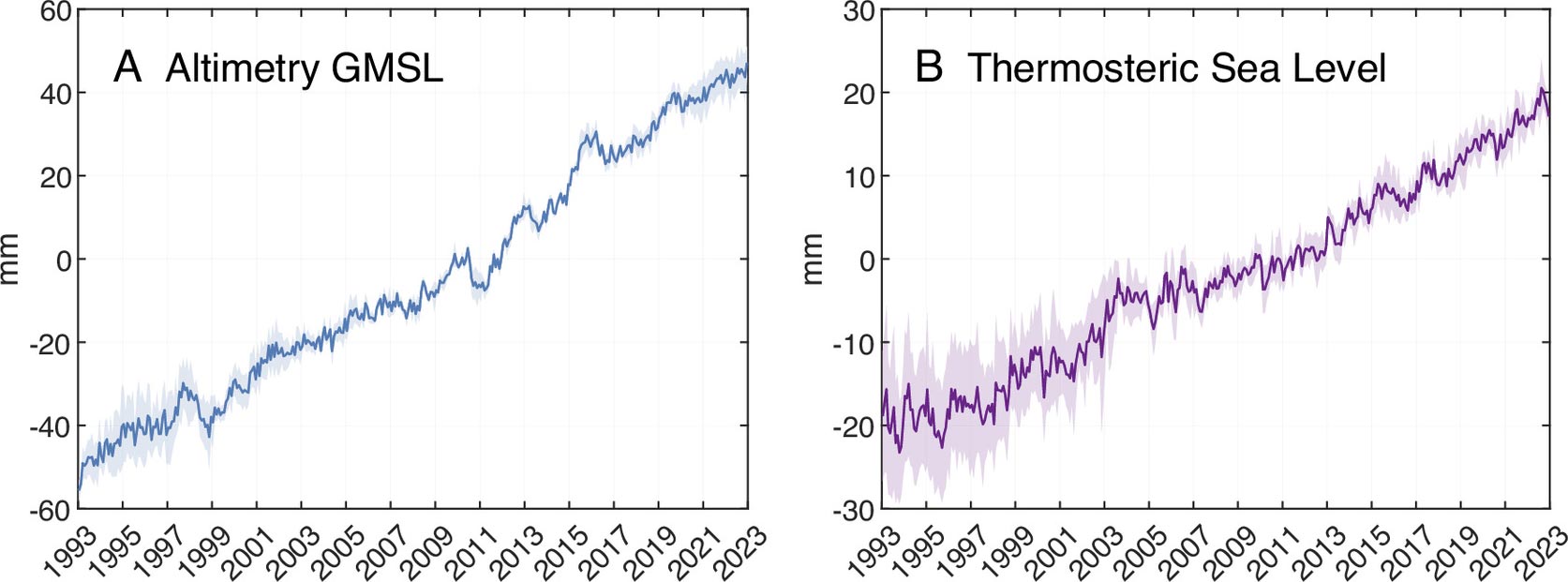
Two major processes cause the global average sea level to rise: one is the thermal expansion of sea water (the ocean absorbs about 90% of the excess heat from the earth's climate system); the other is the increase in ocean mass caused by the melting of land ice and snow. Therefore, continued monitoring of changes in ocean mass is critical to understanding current sea level trends.
The research team, led by Chen Jianli, chair professor of space geodesy and earth sciences in the Department of Land Surveying and Geoinformatics at PolyU, and co-research assistant professor Nie Yufeng, used time-varying gravity field data obtained by satellite laser ranging (SLR) for the first time to directly estimate global ocean mass changes from 1993 to 2022.
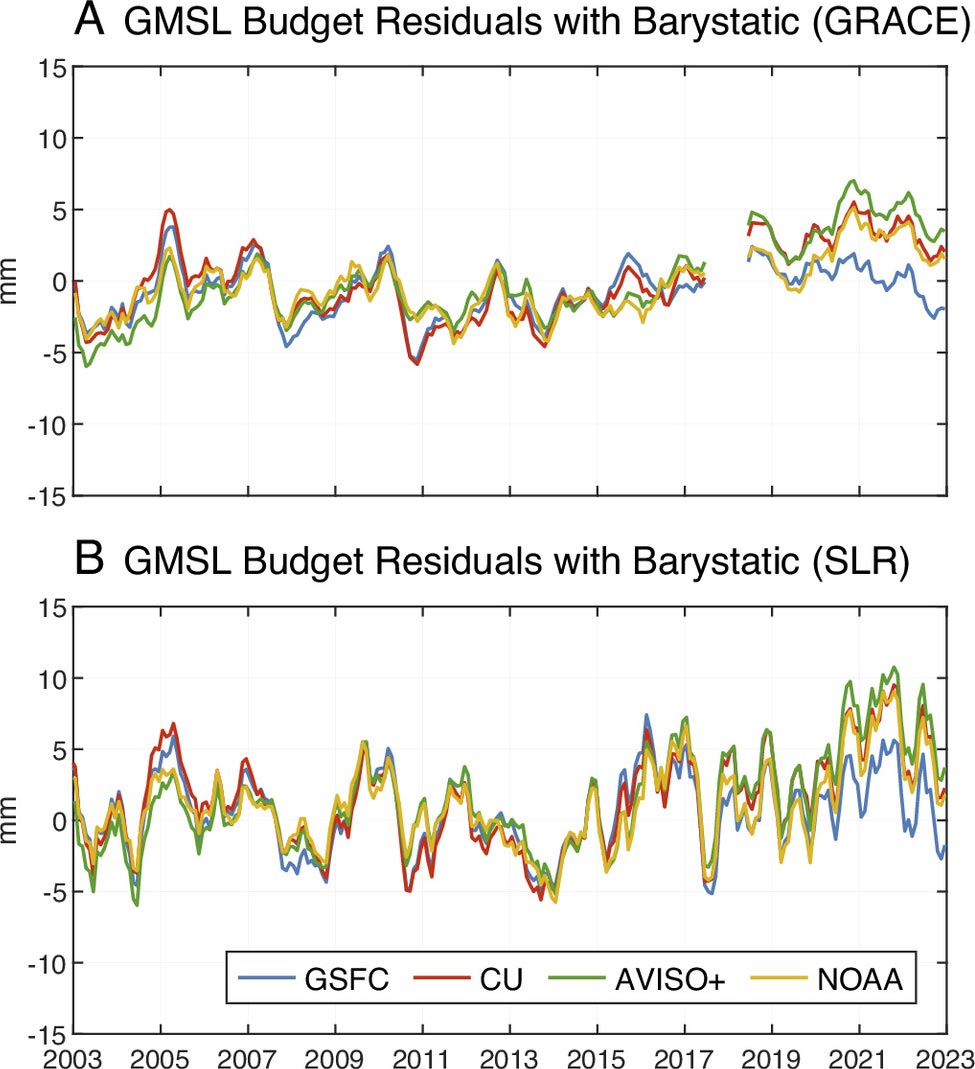
Previously, projections of sea level rise mainly relied on satellite altimetry. It was not until the launch of the Gravity Recovery and Climate Experiment (GRACE) project in 2002 that it was possible to record ocean gravity hydrostatic sea levels through satellite gravity measurements. As a mature geodetic survey method, SLR accurately measures the distance between ground stations and satellites through laser pulses. However, due to historical limitations such as the limited number of satellites and ground stations, high orbital altitude (only able to detect long-wave gravity changes), and low observation resolution, SLR is difficult to be directly used to accurately estimate ocean mass changes.
To break through this limitation, the research team introduced a forward modeling method that includes detailed land-sea boundary information, significantly improving the spatial resolution and making long-term monitoring of global ocean quality based on SLR possible.
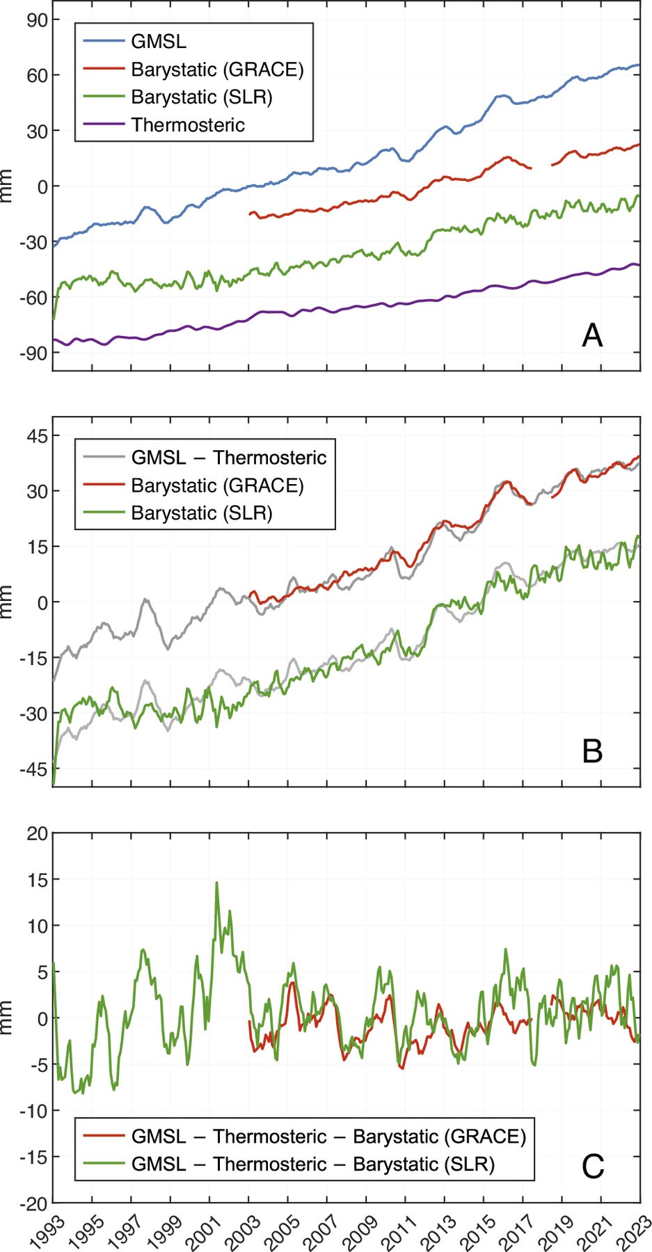
Research reveals that global mean sea level will rise by a total of approximately 90 millimeters from 1993 to 2022, of which approximately 60% is attributed to the increase in ocean mass. Since 2005, dramatic increases in ocean mass have become the primary driver of global sea level rise. Throughout the study period, the accelerated melting of ice and snow in polar and mountainous areas such as Greenland contributed more than 80% of the increase in global ocean mass.
Professor Chen Jianli said: "In recent decades, climate warming has led to increased loss of land ice, which has become the dominant force driving global sea level rise. Our study can directly quantify the increase in global ocean mass, make a comprehensive assessment of the multi-year sea level budget, and provide key data for testing future sea level change models and scenario predictions."
Dr. Nie Yufeng added: "The ocean mass changes obtained by SLR analysis are highly consistent with the total sea level changes observed by satellite altimetry (after excluding the effect of thermal expansion), showing that the traditional SLR method can now be used as a new and powerful tool in the study of long-term climate change."
This research was supported by the National Natural Science Foundation of China, the Collaborative Research Fund of the Hong Kong Research Grants Council, and the internal funds of the Department of Land Surveying and Geoinformatics of the Hong Kong Polytechnic University.