
Abstract:
A study recently published in PNAS, the Proceedings of the National Academy of Sciences, shows that glaciers in the mountainous areas of the western United States are shrinking significantly. Researchers conducted a systematic assessment of more than 1,000 glaciers across six states in the western United States and found that about 27% of glaciers have completely disappeared since the mid-20th century, with both total glacier area and total volume reduced by about one-third. This change not only reflects long-term shifts in climate and hydrological conditions in the mountains, but may also reduce the ability of glaciers to provide water to rivers and ecosystems during hot and dry seasons.

This study is titled "The Massive Disappearance of Glaciers in the Contiguous United States" and was published in the "Proceedings of the National Academy of Sciences" on October 12, 2026. The research team consisted of Portland State University geologist Andrew Fontaine, U.S. Geological Survey researcher Bryce Glenn, University of Northern British Columbia researcher Christopher McNeil, and Brian Menounus.
The study covered major mountain ranges in the contiguous western United States, including the Cascades, Rockies and Sierra Nevada, and involved Washington, Oregon, California, Montana, Wyoming and Colorado. The glaciers here are distributed in different altitudes and climate environments. There are glaciers in the northwest affected by the humid climate of the Pacific Ocean, and relatively small glaciers located in dry mountainous areas inland.
Researchers pointed out that although glaciers play an important role in the hydrological system of mountainous areas of the western United States, previous comprehensive quantitative assessments of glacier area and volume changes across the entire western United States have been insufficient. Past studies tended to focus on a certain mountain range or a specific area, making it difficult to comprehensively present the changes in glaciers in the entire western mountainous area.
To fill this gap, the research team compared historical glacier inventories from the mid-20th century with glacier inventories established through aerial and satellite imagery in recent years, and combined topographic data to estimate glacier thickness, volume and changes.
Historical data mainly comes from 1:24,000 scale topographic maps drawn by the United States Geological Survey. The relevant maps were not completed in the same year, but were drawn one after another from the early 1950s to the mid-1980s. Modern data mainly come from aerial, satellite and lidar measurements obtained from about 2014 to 2020. Because the data collection time in different areas is not consistent, the researchers used corresponding time ranges for comparison, rather than simply attribute the changes of all glaciers to a precise year.
Research results show that in the historical inventory, there are 1,453 glaciers in the western United States, covering a total area of approximately 561.8 square kilometers. As of the modern inventory around 2015, the number of glaciers is 1,331, with a total area of approximately 366.5 square kilometers.
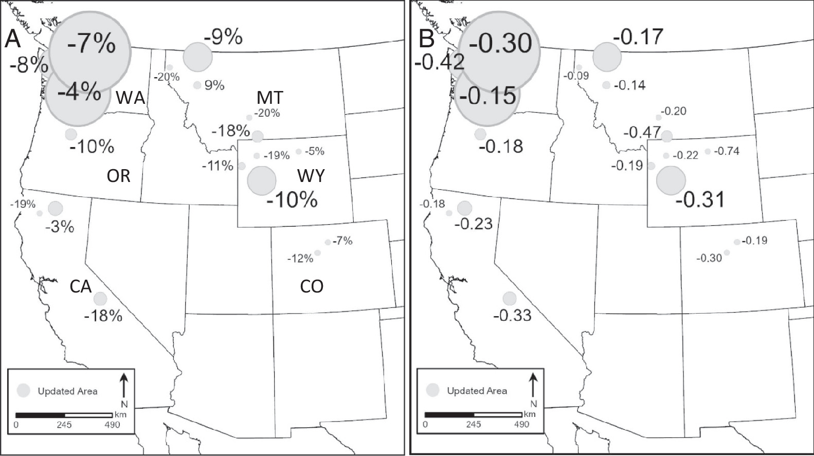
From an area perspective, glacier coverage decreased by approximately 195.3 square kilometers, a decrease of approximately 35%. Calculated based on the historical and modern data time span used in the study, the glacier area decreases by an average of about 1.1 square kilometers per year, which is equivalent to a decrease of about 8% every decade.
Judging from the number of glaciers, 398 of the 1,453 glaciers in the historical inventory have disappeared in the modern inventory, accounting for about 27% of the original number. This result shows that glacier retreat is not only characterized by thinning and shrinking of the original ice body, but also means that some smaller glaciers have completely disappeared.
However, changes in the number of glaciers alone do not reflect the full extent of ice loss. Some glaciers may split into multiple independent ice bodies during the retreat process, increasing the number of glaciers in statistics. For example, in the Cascade Mountains of northern Washington state, some glaciers have retreated and split into different tributaries, or tongues, causing modern inventories to record a higher number of glaciers than historical data. Comparing only the number of glaciers may underestimate the extent of overall glacier retreat.
So the researchers simultaneously analyzed changes in glacier area, thickness and volume. The results show that while the glacier area decreases, the thickness of the ice body also generally decreases. After an area-weighted calculation of all glacier-covered areas, the average thickness decreased by about 11.6 meters, and the average rate of change was about 0.26 meters per year.
There are obvious differences in the rate of glacier retreat in different regions. Overall, areas outside of Washington state have experienced greater reductions in glacier size. Researchers estimate that glaciers outside Washington state have declined by about 52% on average, while glaciers within Washington have declined by about 29% on average. However, since the historical mapping years and modern imaging years in different regions are not the same, these figures reflect the cumulative changes in the corresponding observation periods in each region and are not direct comparisons of exactly the same time periods.
The retreat is especially pronounced in smaller glaciers. The study found that the area of small glaciers with a historical area between 0.032 and 0.10 square kilometers has decreased by about 67% on average; while the area of larger glaciers with a historical area between 3.16 and 10 square kilometers has decreased by about 15% on average.
This difference shows that small glaciers are more sensitive to changes in the surrounding environment. Larger glaciers generally have thicker ice bodies and larger water storage volumes, which can buffer short-term climate fluctuations to a certain extent. Small glaciers may lose a significant proportion of their ice mass in a relatively short period of time, and are more likely to disappear completely once the accumulated ice volume is insufficient to offset melting.
Researchers believe that the generally smaller size of glaciers in the western United States is an important factor in understanding this change. Many glaciers do not rely on the continuous accumulation of ice and snow in large-scale, high-altitude areas, but are affected by local topography, shadows, slope aspects, and snow accumulation conditions. Some glaciers can exist mainly because the surrounding mountains block the sun, or the terrain is conducive to the accumulation of snow, thus forming a locally favorable glacier environment.
This dependence on local topography means that when temperatures rise, snowfall decreases, or snow melts earlier, glaciers can quickly lose their original survival conditions. Even within the same mountain range, different glaciers may retreat at different rates due to differences in altitude, slope aspect, and surrounding terrain.
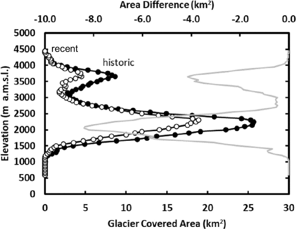
The study also found that the highest area distribution position of the glacier-covered area in the western United States has moved about 50 meters to a higher altitude. This shows that the loss of glaciers in low-altitude areas is relatively more serious, and the remaining glaciers are gradually concentrated in higher and colder areas.
From a regional perspective, the Pacific Northwest contains most of the glaciers in the western United States. Research shows that northwest regions such as Washington State and Oregon have about 81% of the number of glaciers and about 89% of the glacier area. The local climate is relatively humid and snow conditions are generally more favorable than in the mountainous interior of the United States, so the glaciers are more widely distributed.
In contrast, the climate in some mountainous areas in California, Wyoming, Colorado and southern Montana is drier. Glaciers are usually located in high mountain areas above 3,000 meters above sea level, and the overall size is smaller. In these areas, glaciers tend to be more vulnerable to changes in snowfall and rising temperatures.
In the Biltos Mountains and Absaroka Mountains in southern Montana, researchers have discovered significant glacier thinning. The average thickness of the 44 glaciers in this area decreased by about 16.2 meters during the corresponding observation period, and the average thickness decreased by about 0.47 meters per year. It is one of the areas with the highest thinning rate among mountain areas with at least 10 glaciers according to research statistics.
In contrast, glaciers in the Cascade Mountains of southern Washington state have thinned relatively little, with an average thickness reduction of about 7.2 meters and an average annual decrease of about 0.15 meters. Results in this region are primarily influenced by large glacier systems such as Mount Rainier.
The researchers also emphasized that glacier changes are not entirely determined by climate factors. When Mount St. Helens erupted in 1980, volcanic activity directly caused the destruction of some small glaciers, and at the same time, new glaciers were formed in the crater. The team therefore excluded changes in these glaciers, which were directly affected by volcanic eruptions, from the main climate change analysis to avoid mistaking the effects of volcanic activity for long-term climate change.
One of the most noteworthy implications of this study is that the loss of glaciers will change the way water is supplied in the mountainous areas of the American West.
A glacier can be thought of as a natural reservoir that stores water over a long period of time. The snow and ice accumulated in winter do not melt all at once, but are able to retain moisture for a longer period of time and gradually release it during the warm season. Especially in summer, when seasonal snowpack has melted and precipitation has decreased, glacier meltwater can still provide water for mountain rivers.
This moderating effect is important to the American West. Some rivers and ecosystems in the region rely on mountain meltwater to maintain summer flows. Glacier meltwater can alleviate water shortages during hot and dry periods and provide cooler water sources for mountain lakes, streams and downstream ecosystems.
For aquatic organisms that rely on cold water environments, glacier meltwater not only provides water, but also helps maintain lower water temperatures. As glaciers shrink, rivers may lose part of their cold water supply from glaciers in summer, increasing the risk of water temperatures rising, affecting fish and other aquatic organisms adapted to low-temperature environments.
Glacier retreat also reduces the ability of mountainous watersheds to cope with drought. The researchers note that the smaller the glacier, the less capable it is of regulating seasonal water flow. When snow melts earlier, summer temperatures rise and precipitation falls short, glaciers find it difficult to replenish river flows as they did in the past.
This does not mean that reduced meltwater from glaciers will immediately lead to a water crisis across the western United States. The water source structure varies greatly in different regions, and river flow is also affected by various factors such as rainfall, seasonal snow, groundwater, artificial reservoir operation, and water demand. But continued shrinking of glaciers does reduce the natural water reserves that some mountainous watersheds can rely on during hot and dry periods.
The researchers also noted that other water reserves in the western United States are also under pressure. As the climate warms, winter precipitation in some areas occurs in the form of rain rather than snow, and seasonal snow reserves decline. At the same time, artificial reservoirs are also affected by factors such as reduced inflows, increased evaporation and rising water demand.
In this context, the importance of glaciers as natural reservoirs becomes even more prominent. They can compensate to some extent for water gaps caused by seasonal reductions in snow cover, but as glaciers shrink, this buffering capacity will continue to decline.
It is worth noting that melting glaciers may increase the amount of water flowing into rivers in the short term, but this does not mean that water supplies will increase permanently. The release of stored ice water during the retreat of glaciers may temporarily increase the amount of melt water in certain periods; as the ice mass continues to decrease, the amount of stored water that can be released will eventually decrease. For watersheds that rely on glacier meltwater, the long-term impact could be more unstable water sources in the summer, rather than continued access to more water.
The researchers also found that a few glaciers expanded slightly during the observation period. According to research statistics, the area of 51 glaciers has increased, accounting for about 4% of the modern inventory, with a total increase of about 1.25 square kilometers. These local increases do not change the overall trend of significant glacial shrinkage across the region.
This also shows that glacier changes are not exactly the same in all locations. Localized snowfall, topographic conditions, accumulations of wind-blown snow, and other environmental factors can cause individual glaciers to remain stable or even expand at certain times. But looking at comprehensive data across the entire western United States, glacier area and volume reduction remains the dominant long-term trend.
The research team believes that this result provides an important benchmark for understanding the ongoing changes in the alpine hydrological system of the western United States. In the past, researchers have documented glacier retreat in several mountainous areas, but a unified assessment covering the entire western United States was lacking. By integrating historical maps, modern remote sensing data and topographic survey data, this study conducted the first systematic analysis of changes in area, volume and ice volume of all identified glaciers in the region.
This study does not attempt to predict when each glacier will disappear based on historical data alone, nor does it provide a unified timetable for the future disappearance of all glaciers. Its main contribution is to clearly document the changes that have occurred in the number, area, and thickness of glaciers in the western United States from the mid-20th century to about 2015, and to explain the impact these changes may have on mountain hydrological systems.
Overall, the shrinking of glaciers in the western contiguous United States is not only a change in the alpine landscape, but also a sign that water resources systems are transforming. About 27% of glaciers have disappeared and the total area has decreased by about 35%, which means that a large number of natural ice bodies that once stored water for a long time have shrunk or no longer exist. As remaining glaciers continue to shrink, their ability to recharge rivers with cold water and buffer fluctuations in water volume during hot and dry seasons may also decline further.
For the western United States, future water resources management must not only focus on rainfall, snowpack and artificial reservoirs, but also need to consider the long-term effects of the gradual decline of glacial water storage capacity. Glaciers themselves are small, but they can play an important role in certain seasons and in certain watersheds. The comprehensive data provided by this study will help scientists and water managers more accurately assess the future drought risks faced by alpine regions and the pressures that ecosystems may be under.
Comments