
Abstract:
A super strong El Niño event is forming in the Pacific Ocean that may break the historical record of 1997. NASA is using satellites to continuously monitor changes in the ocean. The latest observations show that there are clear similarities between the ocean conditions in 2026 and the famous strong El Niño event from 1997 to 1998, but scientists emphasize that the similar ocean signals do not mean that global weather will definitely repeat itself.
El Niño is the warm phase of the El Niño-Southern Oscillation (ENSO) climate system, which usually occurs every 2 to 7 years. Its formation is related to the interaction between equatorial Pacific ocean water temperatures, trade winds, and atmospheric circulation. Under normal circumstances, trade winds near the equator push warm surface water from the American side to the western Pacific, causing a large amount of warm water to accumulate near Asia and Australia, while cooler deep water rises near South America.
When the trade winds weaken, the warm water originally accumulated in the western Pacific will move to the central and eastern parts of the Pacific. Warming seawater will further weaken the trade winds, forming a mutually reinforcing feedback mechanism that will gradually strengthen El Niño. As warm water spreads eastward, the heat and water vapor released from the ocean into the atmosphere will also change global atmospheric circulation, thereby affecting rainfall, temperatures and storm activity in many regions.
NASA scientists mainly used satellite altimeters to monitor sea level changes. As seawater heats up, it expands thermally, so sea level can be an important indicator of ocean heat accumulation. By comparing satellite data from different years, the researchers were able to determine how widespread the warm water in the equatorial Pacific is and how far it is spreading toward the coast of South America.
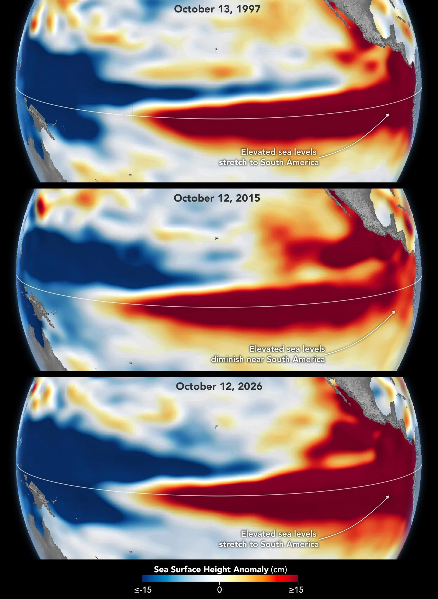
Scientists from NASA's Jet Propulsion Laboratory (JPL) used satellite observation data from October 13, 1997, and October 12, 2026 for comparison. The former comes from the TOPEX/Poseidon satellite, and the latter comes from the Sentinel-6 Michael Freilich satellite. Both sets of data were processed to remove seasonal changes and long-term sea level rise trends in order to highlight short-term ocean anomalies caused by El Niño.
The comparison results show that in 2026, the sea level in the western equatorial Pacific will be low, while the sea level in the central and eastern parts will rise significantly, and warm water has extended to the coast of South America. This is very similar to the ocean structure in the fall of 1997. Josh Willis, sea level observation project scientist at NASA's Jet Propulsion Laboratory, said that satellite altitude measurement technology has about 35 years of continuous observation records, and there are data connections between different satellite missions, so researchers can more reliably compare current ocean conditions with 1997. He believes that the current development trend of El Niño may even exceed the scale of that year.
The 1997-1998 El Niño was one of the strongest events in the history of modern meteorological observations. At that time, severe weather abnormalities occurred in many regions around the world, including large-scale fires in Indonesia and the Amazon, crop yield losses caused by drought in southern Africa, and heavy rainfall and coastal flooding in southern California in the United States. The United Nations has estimated that this El Niño caused more than 20,000 deaths worldwide and caused approximately US$36 billion in infrastructure losses.
However, the super strong El Niño in 2015-2016 also showed that the intensity of ocean temperature anomalies does not completely determine its weather effects. Although that event was also very strong, the distribution of warm water was different from that in 1997. In October 2015, the high sea level area in the equatorial Pacific, although clearly evident, did not extend to the coast of South America as extensively as in 1997. Therefore, the impact of winter rainfall that year was more concentrated in Central America and the southeastern United States, and severe flooding also occurred in Mexico.
This is why scientists are reluctant to simply predict that the weather in 2026 will be exactly like 1997. El Niño's impact on global weather depends not only on the size of the ocean's warm water, but also on where the warm water is concentrated and how the atmospheric circulation responds. Even if ocean conditions are very similar between two years, the eventual distribution of rainfall, droughts, and storms may be different.
The U.S. National Oceanic and Atmospheric Administration (NOAA) pointed out in the climate outlook released on October 8, 2026 that the probability of a strong to extremely strong El Niño from the winter of 2026 to early 2027 reaches 83%. The agency believes this event has the potential to be the strongest since 1950. However, uncertainties in weather forecasts remain, especially as El Niño effects spread from the tropical Pacific to other parts of the world, and complex changes in atmospheric systems can make long-term predictions more difficult.
Josh Willis said that even if the current ocean conditions are highly similar to those in 1997, it cannot be concluded that the exact same weather will definitely occur in the winter of 2026-2027. He described this prediction as a probability judgment with uncertainty, rather than a certain outcome.
NASA will continue to use Earth observation satellites to track Pacific sea temperatures, sea levels and other ocean changes. For agricultural production, forest fire prevention and control, and flood control in coastal areas, early identification of the development trend of strong El Niño is of great significance. Scientists hope that through continuous observations, governments and related industries can gain more preparation time and reduce the losses that may be caused by extreme weather.
Whether this developing El Niño will eventually exceed the 1997 record remains to be confirmed by follow-up observations. But current satellite data has shown that the Pacific Ocean in 2026 is showing an ocean structure worthy of great concern. The atmosphere's response to ocean anomalies in the coming months will be key to determining the ultimate impact of this climate event.
Comments