
Abstract:
The water level in Lake Powell (Lake Powell), an important water source in the western United States, fell to the lowest level on record in the summer of 2026. Satellite images released recently by the National Aeronautics and Space Administration (NASA) show that the continued lack of snow and abnormally high temperatures have combined to weaken the water flow of the Colorado River, further deteriorating the water storage condition of the second largest reservoir in the United States. The drop in water levels not only threatens local water supply, but also puts greater pressure on hydropower, agricultural irrigation and ecological protection.
 +
+
A report released by NASA Earth Observatory on October 15 pointed out that in the winter from 2025 to 2026, the amount of snow in the mountainous areas of the upper Colorado River basin will be abnormally low. Entering spring, far less snow is able to melt and flow into rivers than in previous years, resulting in a significant lack of seasonal runoff from the Colorado River. At the same time, abnormally high temperatures have occurred in many areas of the western United States, further exacerbating the situation of reduced snow cover and water resources stress.
Lake Powell is located on the border of Utah and Arizona in the United States and was formed by the Glen Canyon Dam intercepting the Colorado River. As one of the most important reservoirs in the western United States, it assumes multiple tasks such as regulating river flow, storing water resources, and providing hydroelectric power. Water management in the Colorado River Basin affects the lives and economic activities of more than 40 million people and provides irrigation water for approximately 5 million acres of farmland.
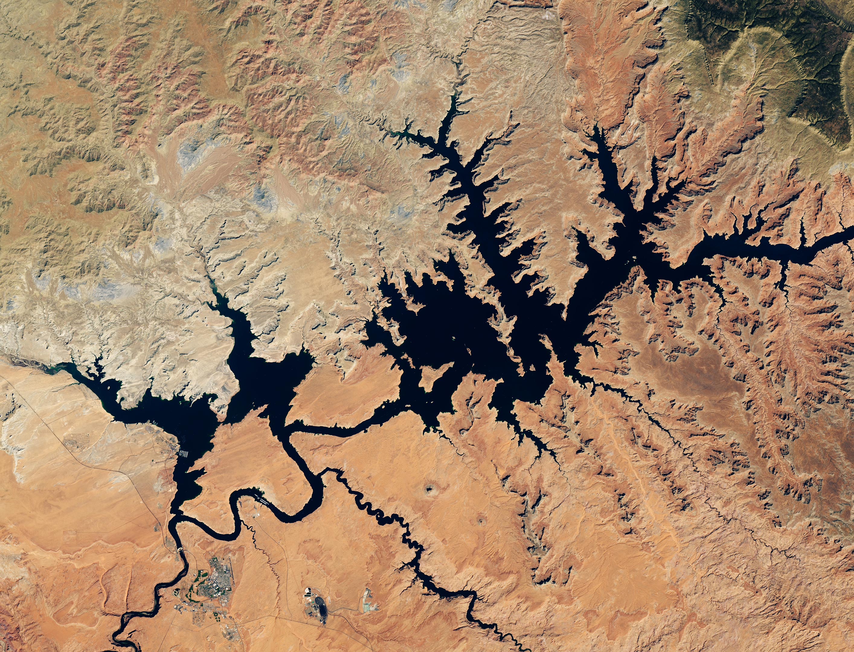
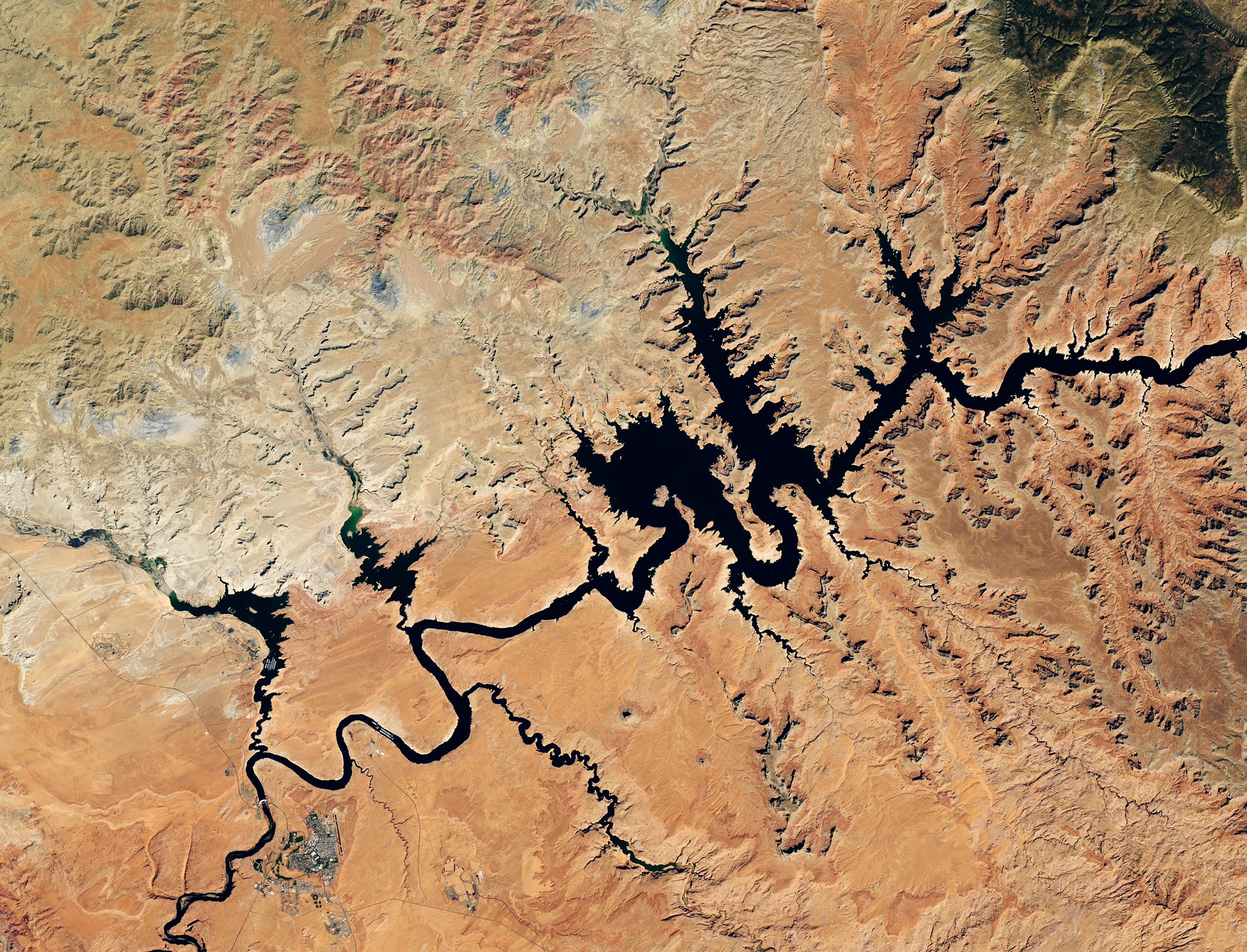
The satellite images released by NASA this time compare the local waters of Lake Powell on September 1, 2017 and September 10, 2026. Images from 2017 show the lake covering a large area upstream of Glen Canyon Dam, when the reservoir was at its fullest level over the past decade. By September 2026, the water surface in the same area shrank significantly, and part of the shoreline and terrain originally covered by the lake were re-exposed.
According to U.S. Bureau of Reclamation data cited by NASA, on September 10, 2026, the water surface elevation of Lake Powell was approximately 3,517.24 feet, or approximately 1,072 meters. Previously, the reservoir had fallen below the record low water level of 3,519.92 feet set on April 13, 2023, at the end of July, and the water level continued to fall thereafter.
The change reflects the more severe impact of a prolonged drought in the western United States. Much of the Colorado River Basin has an arid or semi-arid climate, and the snow accumulated in the mountains during winter is equivalent to a natural reservoir. As the snow melts in spring and early summer, it replenishes rivers and reservoirs with large amounts of water. Therefore, whether the snow cover is sufficient in winter often directly affects the water supply status of the entire basin that year.
However, there will be a significant lack of snowfall in the Upper Colorado River Basin during the winter of 2025-2026. Scientists call this situation of lower than normal snowpack a "snow drought." Different from the lack of rainfall in the general sense, snow drought emphasizes the lack of winter snow in mountainous areas, a key water source reserve. Even if precipitation occurs in some areas in spring, it may not be able to fully make up for the runoff losses caused by insufficient snow cover in winter.
The problem is further exacerbated by unusually high temperatures. Warmer temperatures in mountainous areas can change the timing of snowpack accumulation, melting and disappearance, making it more difficult for an already inadequate snowpack to provide consistent water to rivers at the right times. When the spring snowmelt arrives, there is not much snow left to melt, and the flow of water from the Colorado River is severely affected.
Faced with the continued decline of reservoir water levels, the U.S. Bureau of Reclamation will take emergency measures starting in April 2026 to try to stabilize the water storage level of Lake Powell. Management had warned that without intervention, water levels could fall below critical heights affecting hydropower generation in August of that year.
To relieve pressure, the Bureau of Reclamation began transferring water to Lake Powell from the Fleming Gorge Reservoir in northern Utah and southern Wyoming to replenish water and slow down the decline in water levels. At the same time, the management department reduced the amount of water released from Lake Powell to downstream Lake Mead and readjusted some of the original water resource dispatch plans.
Some water release arrangements originally used for ecological protection have also been canceled or postponed. The Bureau of Reclamation canceled a controlled flood release originally planned for April. Such operations, often by increasing the amount of water released for a short period of time, help rebuild riverbank sandbars and provide habitat for fish and other wildlife. In addition, the management department also canceled a special water release operation originally planned for August, which was originally intended to help protect local native species by regulating water temperature.
These adjustments reflect the dilemma faced by water resources management: when reservoir storage capacity is insufficient, management departments must make difficult choices between maintaining hydropower generation, ensuring downstream water supply, and protecting river ecology. Even if certain ecological protection measures have long-term value, under extreme drought conditions management may have to prioritize maintaining a reservoir's basic operating capacity.
The crisis at Lake Powell is not an isolated incident. Lake Mead, located downstream, also fell to a record low level in August 2026. The two reservoirs together form an important part of the Colorado River water management system. Once the water storage capacity decreases at the same time, water management pressure will increase significantly throughout the southwestern United States.
The Colorado River Basin spans multiple states and involves urban, agricultural, and industrial water needs in different regions. Cities such as Las Vegas, Phoenix, Los Angeles and San Diego all rely on the water provided by this basin. Reduced reservoir water storage may not only make urban water supply management more difficult, but may also affect agricultural production, hydropower generation, and ecosystems along rivers.
What is even more worrying is that the drought in the southwestern United States has lasted for more than two decades. Researchers often refer to this period as a "megadrought," which is characterized by long duration, widespread impacts, and cumulative impacts on soil moisture, snowpack storage, river runoff, and groundwater recharge. Even if more precipitation occurs in some years, long-term depletion of water reserves may not be quickly restored.
In this context, the decline in reservoir water levels is not just the result of insufficient snowfall in a certain year, but a manifestation of the combination of long-term climate drought and abnormal climate conditions that year. As water reserves continue to come under pressure, management needs to more accurately determine the changing relationship between snowpack, soil moisture, groundwater and surface water in order to develop water supply and dispatch plans in advance.
Multiple projects supported by NASA are providing data and technical support for related work. Among them, the monitoring platform based on the Western Land Data Assimilation System (WLDAS) can display information such as soil moisture, snow moisture content, and evapotranspiration in the headwaters of the Colorado River. The data helps researchers assess the state of mountain water reserves and inform Colorado's drought response efforts.
Around Lake Powell, NASA is also working with the Navajo Nation and other institutions to develop drought severity assessment tools to track local precipitation changes, vegetation health and other drought indicators. The tool helps communities identify areas of greater water stress and informs land management and drought response decisions.
In addition, Arizona State University collaborated with the Central Arizona Project to develop the Colorado River Comprehensive Assessment Tool, which integrates snow cover, surface water, groundwater storage and soil moisture information into the same platform and uses NASA satellite observation data for verification. By combining satellite remote sensing, ground measurements and computer models, researchers hope to get a more complete picture of water resource changes across the basin.
These technologies cannot directly solve the problem of insufficient snowfall, but they can help management departments detect risks earlier and improve the accuracy of water resource dispatching. For areas that rely on seasonal snowmelt to replenish water sources, judging changes in snow storage and runoff in advance may buy more adjustment time for urban water supply, agricultural irrigation, and hydropower generation.
Lake Powell's record low water levels highlight the vulnerability of the western United States' water system to a prolonged drought. In the future, even if snowfall in mountainous areas returns to normal, reservoirs may not be able to quickly return to their past water storage levels, because the recovery process also depends on subsequent precipitation, river runoff, evaporation losses, and upstream and downstream water demand.
As climate conditions continue to change, how to balance urban life, agricultural production, energy supply and ecological protection with limited water resources will become a long-term core issue facing the Colorado River Basin. Lake Powell's latest water level record is not only a hydrological data point, but also another reminder that for arid regions that rely on mountain snowmelt for water, a lack of winter snowpack can turn into a water crisis affecting the lives of tens of millions of people in a few months.
Comments